
Volume 2 Issue 2, Feb 2013
|
Winter Hazards: Freezing Spray and Sea Ice
By: Sarah Finnerty, Meteorologist
|

|
Stronger storms, stronger winds, larger seas, and reduced visibility.
These are likely a mariner's first thoughts when discussing winter-time
hazards. An often overlooked and more challenging aspect of winter-time
routing is ice (both sea ice and freezing spray), which can cause
routing and safety concerns in the high latitudes during the winter
months.
Freezing spray involves several factors which determine the severity and rate of ice accumulation. Wind speed generally needs to be greater than 15-20kts and air temperatures must be below 0° Centigrade in order to freezing spray to occur. Additionally, colder sea surface temperatures and larger waves (which produce more sea spray) will result in an increased risk of structural icing.
The rate of freezing spray/structural icing is typically defined as follows:
 Sea Ice Limits and Freezing Spray forecasts are
now available on Dolphin! These tools assist our clients and vessels in
prosecuting safe and efficient voyages while transiting through the high
latitudes.
Sea Ice Limits and Freezing Spray forecasts are
now available on Dolphin! These tools assist our clients and vessels in
prosecuting safe and efficient voyages while transiting through the high
latitudes.
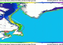
Sea Ice data is derived from the National Ice Center and the National Center for Environmental Prediction (NCEP) using a combination of satellite-derived data and real-time analysis, and is updated daily (Figure 1 and Figure 2). Sea Ice data charts on Dolphin are
 high-resolution, with the ability
to zoom in for detailed analysis at
any location. This data can be accessed directly from the Dolphin
website, or provided as an email attachment.
high-resolution, with the ability
to zoom in for detailed analysis at
any location. This data can be accessed directly from the Dolphin
website, or provided as an email attachment.
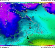
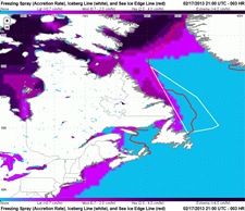
WRI has added two new parameters on Dolphin that assist our clients to minimize/avoid freezing spray threats. Dolphin's new air temperature maps with surface pressure overlay (Figure 3) provide a detailed analysis of regions where air temperatures are cold enough to support freezing spray. Dolphin's new Freezing Spray forecast maps (Figure 4) combine all meteorological and oceanographic factors that can lead to structural icing into one convenient product. These maps highlight regions where freezing spray is likely to occur, along with the potential accretion rates. Iceberg limits and Sea Ice edge data are also provided. Freezing Spray potential forecast maps extend out beyond 7 days, with high-resolution images that can be accessed directly from Dolphin or emailed to the vessel.
 WRI's experienced marine meteorologists and route analysts can also
provide recommendations for specific routes or course headings that a
vessel should follow in order to minimize or avoid ice accretion. We
take all of these factors into account to keep the vessel safe, while
minimizing added distance and time to the transit in order to help save
bunker and operating costs. Figure 5 shows two routes which are almost
identical in distance. However, the western, purple route spends very
little time in freezing spray while the eastern, black route transits in
freezing spray for the vast majority of the voyage.
WRI's experienced marine meteorologists and route analysts can also
provide recommendations for specific routes or course headings that a
vessel should follow in order to minimize or avoid ice accretion. We
take all of these factors into account to keep the vessel safe, while
minimizing added distance and time to the transit in order to help save
bunker and operating costs. Figure 5 shows two routes which are almost
identical in distance. However, the western, purple route spends very
little time in freezing spray while the eastern, black route transits in
freezing spray for the vast majority of the voyage.
Utilizing WRI's Dolphin website and our detailed route/weather advisories will keep your operations team well advised of potential winter-time hazards and allows your vessels to minimize or avoid dangerous icing threats. Our team of experienced marine meteorologists are constantly watching your vessels and providing the tools and advice for safe and efficient voyages.

If you are interested in our services or if we can assist with any weather-related advice, please call us at 1-518-798-1110 or email us at wri@wriwx.com. Our meteorologists are always available 24/7/365 for consultation.
Freezing Spray
Freezing spray, or ocean water spray which freezes on the
hull/deck, can become very hazardous as ice quickly accumulates on a
vessel. Not only does it pose a direct hazard for the crew on deck, but
it also can severely alter the stability of the ship. In extreme cases,
several tons of ice can accrue and the vessel could flounder and
capsize.
Freezing spray involves several factors which determine the severity and rate of ice accumulation. Wind speed generally needs to be greater than 15-20kts and air temperatures must be below 0° Centigrade in order to freezing spray to occur. Additionally, colder sea surface temperatures and larger waves (which produce more sea spray) will result in an increased risk of structural icing.
The rate of freezing spray/structural icing is typically defined as follows:
- Light: <0.7 cm/hour
- Moderate: 0.7-2.0 cm/hour
- Heavy: 2.0-4.0 cm/hour
- Extreme: >4.0 cm/hour
Sea Ice
Sea ice can pose problems for shipping, especially in the North
Atlantic or North Pacific during the winter. Certain shipping lanes can
be restricted or even closed (Belle Isle Strait and northern China
ports, for example) depending on the thickness of the sea ice. In the
winter months in the Northern Hemisphere, sea ice can reach as far south
as the Sea of Japan and Bohai Sea, China (approximately 37°N). In the
Antarctic, sea ice only develops along the periphery of Antarctica and
extends northward at its greatest extent to approximately 55°S.
WRI's Dolphin Can Help
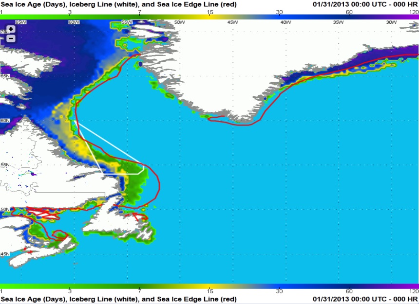
Figure 1: Ice Limits and Age across Gulf of St. Lawrence, Labrador Sea, and along Greenland.
(click to enlarge)
Sea Ice data is derived from the National Ice Center and the National Center for Environmental Prediction (NCEP) using a combination of satellite-derived data and real-time analysis, and is updated daily (Figure 1 and Figure 2). Sea Ice data charts on Dolphin are
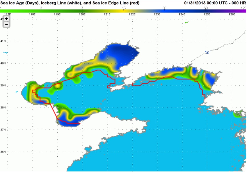
Figure 2: Ice Limits and Age across
the Yellow Sea and Bohai Sea
(click to enlarge)
the Yellow Sea and Bohai Sea
(click to enlarge)
WRI has added two new parameters on Dolphin that assist our clients to minimize/avoid freezing spray threats. Dolphin's new air temperature maps with surface pressure overlay (Figure 3) provide a detailed analysis of regions where air temperatures are cold enough to support freezing spray. Dolphin's new Freezing Spray forecast maps (Figure 4) combine all meteorological and oceanographic factors that can lead to structural icing into one convenient product. These maps highlight regions where freezing spray is likely to occur, along with the potential accretion rates. Iceberg limits and Sea Ice edge data are also provided. Freezing Spray potential forecast maps extend out beyond 7 days, with high-resolution images that can be accessed directly from Dolphin or emailed to the vessel.
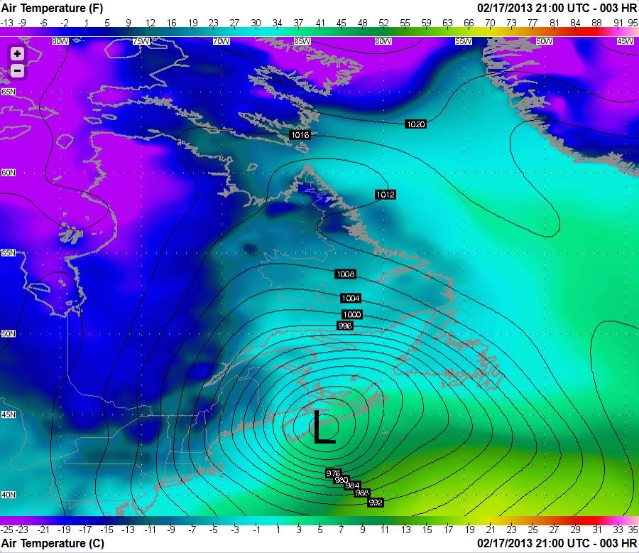
Figure 3: Air Temperature
(click to enlarge)
(click to enlarge)
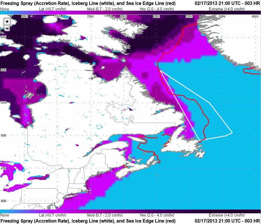
Figure 4: Freezing Spray rates with
Iceberg Boundary and Sea Ice Edges
(click to enlarge)
Iceberg Boundary and Sea Ice Edges
(click to enlarge)
Utilizing WRI's Dolphin website and our detailed route/weather advisories will keep your operations team well advised of potential winter-time hazards and allows your vessels to minimize or avoid dangerous icing threats. Our team of experienced marine meteorologists are constantly watching your vessels and providing the tools and advice for safe and efficient voyages.
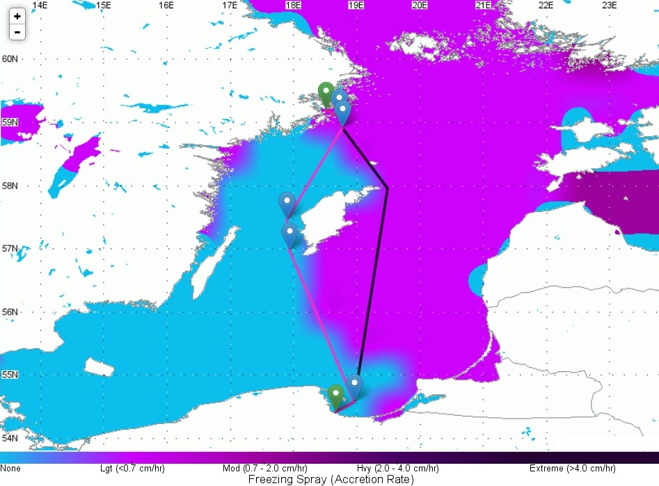
Figure 5: Comparison of two routes using
Dolphin for avoidance of freezing spray
(click to enlarge)
Dolphin for avoidance of freezing spray
(click to enlarge)
If you are interested in our services or if we can assist with any weather-related advice, please call us at 1-518-798-1110 or email us at wri@wriwx.com. Our meteorologists are always available 24/7/365 for consultation.
In this issue:
WRI Services:
Contact us for a Forecast!
wri@wriwx.com
+1-518-798-1110
Dolphin Online Fleet Management
Click Here
Fleet Routing
Click Here
Tropical Surveillance
Click Here
Post Voyage Performance Analysis
Click Here
Route Deviation Anaylsis & Port Consumption Reports
Click Here
Tug & Barge Services
Click Here
Cruise Liner Services
Click Here
 Need a Forecast?
Contact our professional meteorologists
Need a Forecast?
Contact our professional meteorologists
24 hours a day, 365 days a year at
(518) 798-1110
or wri@wriwx.com
WRI Services:
Contact us for a Forecast!
wri@wriwx.com
+1-518-798-1110
Dolphin Online Fleet Management
Click Here
Fleet Routing
Click Here
Tropical Surveillance
Click Here
Post Voyage Performance Analysis
Click Here
Route Deviation Anaylsis & Port Consumption Reports
Click Here
Tug & Barge Services
Click Here
Cruise Liner Services
Click Here
Need a Forecast?
Contact our professional meteorologists24 hours a day, 365 days a year at
(518) 798-1110
or wri@wriwx.com
Unsubscribe