
Volume 2 Issue 7, Nov 2013
|
WRI-CrEWS Elevated Wind Forecasts
By: Brandon Capasso, Senior Meteorologist
|

|
One aspect of observing wind speeds at sea that is often overlooked is differences in wind speed with increasing height above the sea surface.
In general, marine forecasts from both the government and private sectors are given for the lowermost portion of the boundary layer between the sea surface and 10m above, as this is the level of wind that is responsible for sea state. Regardless, stronger elevated winds can cause problems on taller ships. Take, for example, a cruise ship that requires passengers to clear the uppermost deck for safety purposes when wind speeds exceed 30kts. The captain/crew are expecting winds at 20-25kts based on a typical near-surface wind speed forecast, and therefore do not intend to clear the upper deck. Shortly thereafter, the crew finds themselves unexpectedly and frantically trying to clear passengers from the upper deck as actual winds at that level exceed 35kts with gusts to 40kts.
Before we begin this discussion, it is important to understand the definition of boundary layer. To put it simply, the boundary layer is the layer of air between the earth's surface (over land or sea) in which friction from the surface results in drag and therefore slower wind speeds and greater turbulence/gusts within that layer. Subsequently, sustained wind speeds are typically much higher above the boundary layer.

 This concept is not typically a factor in land based forecasts (with the exception of aviation forecasts) due to the fact that when compared
to the marine boundary layer, the depth/thickness of the terrestrial boundary layer is much greater. The reason for this is a combination of
accumulated friction and drag from mountains, trees, buildings, etc. and vertical mixing from daytime heating, which is much stronger over
land than water. Figure #1 demonstrates this concept graphically.
This concept is not typically a factor in land based forecasts (with the exception of aviation forecasts) due to the fact that when compared
to the marine boundary layer, the depth/thickness of the terrestrial boundary layer is much greater. The reason for this is a combination of
accumulated friction and drag from mountains, trees, buildings, etc. and vertical mixing from daytime heating, which is much stronger over
land than water. Figure #1 demonstrates this concept graphically.
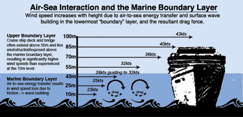
The upper deck/bridge of a tall ship can often sit above the marine boundary layer, which is typically 50-75m above water level. At these levels of the ship significantly higher wind speeds will be observed when compared to winds measured between the sea surface and 10m. Figure #2 demonstrates this concept graphically, and also shows how near-surface (lower boundary layer) wind speeds are reduced due to energy transfer and wave building.
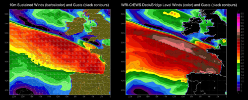
Our WRI-CrEWS (Cruise Elevated Wind Support) product was designed "in house" here at WRI to provide an accurate wind forecast for deck/bridge level by examining the depth of the marine boundary layer and gradient of wind speed with respect to height. The product also analyzes winds well above the marine boundary layer and strength of atmospheric disturbances or "waves" to then determine the peak gust potential in showers/squalls, which can help to transport stronger winds from "higher up" downward and closer to the surface. This results in an accurate assessment of the range of possible wind speeds and eliminates surprises. Figure #3 shows a comparison between the surface/10m wind speed and WRI-CrEWS elevated wind speed forecast.
WRI-CrEWS is also utilized in our port forecasts, as strong elevated beam winds can affect the list and resultant yaw of a ship attempting to dock or navigate narrow passages approaching port. This forecast information is also valuable for sensitive port operations involving tall cranes or rigs (which can be anywhere between 50m-150m tall), where dangerous situations can quickly develop due to higher-than-expected winds.
At WRI, we are constantly working to provide the best weather forecast information available, keeping our clients better informed and prepared for the conditions that they will encounter both in port and at sea. Our innovative tools and detailed advisories will provide your fleet and operations with the information required to ensure safe and efficient transits. Contact WRI today to discuss how our services can be customized for your fleet!
In general, marine forecasts from both the government and private sectors are given for the lowermost portion of the boundary layer between the sea surface and 10m above, as this is the level of wind that is responsible for sea state. Regardless, stronger elevated winds can cause problems on taller ships. Take, for example, a cruise ship that requires passengers to clear the uppermost deck for safety purposes when wind speeds exceed 30kts. The captain/crew are expecting winds at 20-25kts based on a typical near-surface wind speed forecast, and therefore do not intend to clear the upper deck. Shortly thereafter, the crew finds themselves unexpectedly and frantically trying to clear passengers from the upper deck as actual winds at that level exceed 35kts with gusts to 40kts.
Before we begin this discussion, it is important to understand the definition of boundary layer. To put it simply, the boundary layer is the layer of air between the earth's surface (over land or sea) in which friction from the surface results in drag and therefore slower wind speeds and greater turbulence/gusts within that layer. Subsequently, sustained wind speeds are typically much higher above the boundary layer.
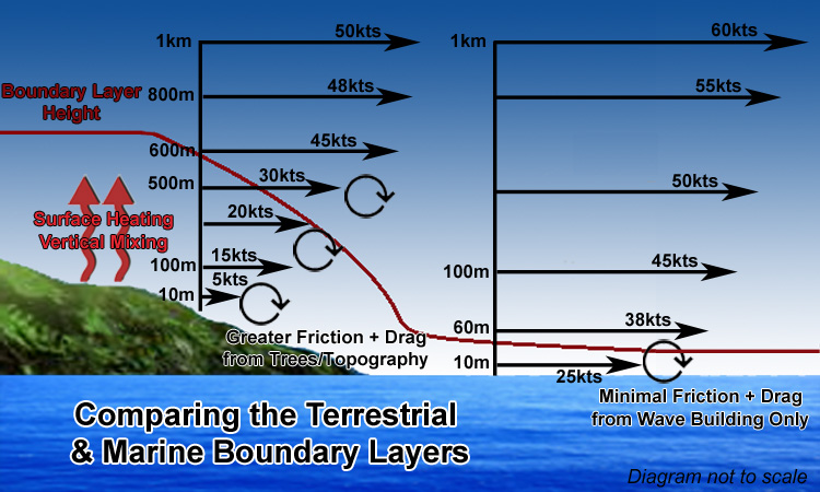
Figure #1 - Differences between the
boundary layer over land and sea.
boundary layer over land and sea.
(click to enlarge)
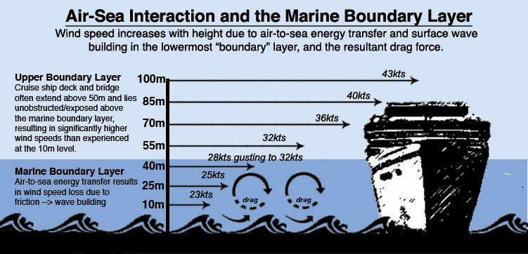
Figure #2 - Air-sea interaction and the
marine boundary layer.
marine boundary layer.
(click to enlarge)
The upper deck/bridge of a tall ship can often sit above the marine boundary layer, which is typically 50-75m above water level. At these levels of the ship significantly higher wind speeds will be observed when compared to winds measured between the sea surface and 10m. Figure #2 demonstrates this concept graphically, and also shows how near-surface (lower boundary layer) wind speeds are reduced due to energy transfer and wave building.
Our WRI-CrEWS (Cruise Elevated Wind Support) product was designed "in house" here at WRI to provide an accurate wind forecast for deck/bridge level by examining the depth of the marine boundary layer and gradient of wind speed with respect to height. The product also analyzes winds well above the marine boundary layer and strength of atmospheric disturbances or "waves" to then determine the peak gust potential in showers/squalls, which can help to transport stronger winds from "higher up" downward and closer to the surface. This results in an accurate assessment of the range of possible wind speeds and eliminates surprises. Figure #3 shows a comparison between the surface/10m wind speed and WRI-CrEWS elevated wind speed forecast.
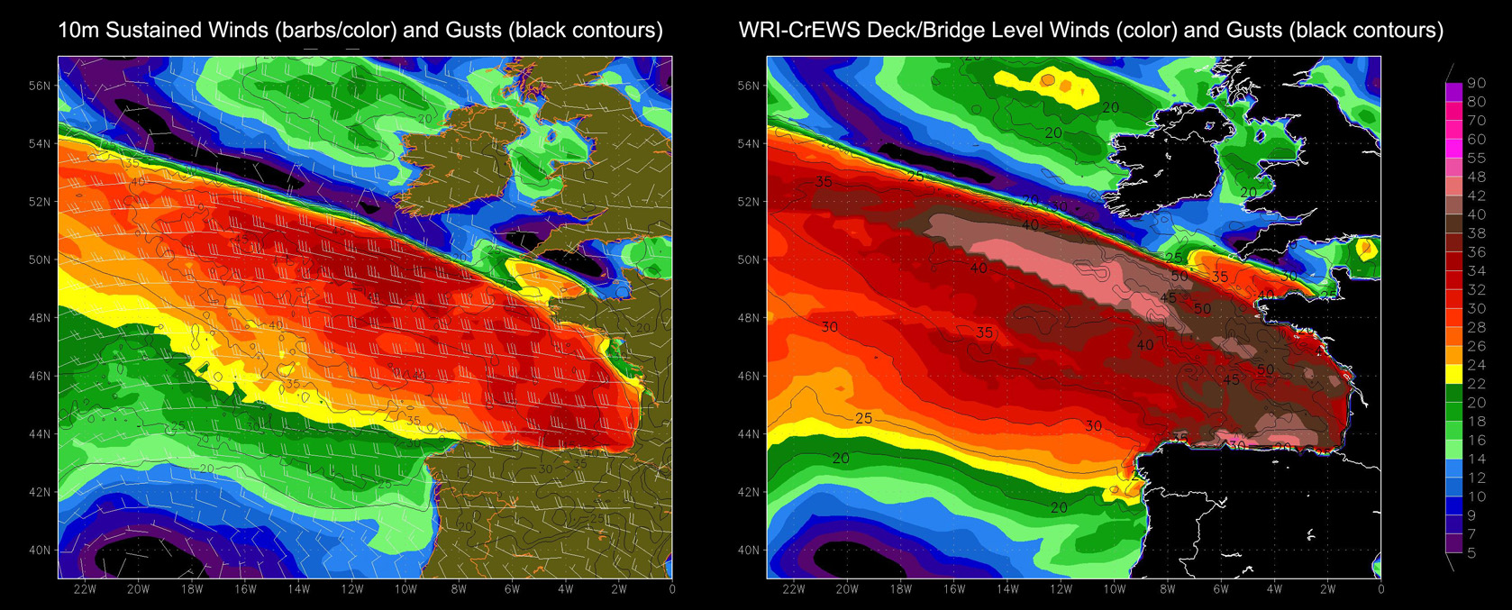
Figure #3 - Comparison between surface and elevated wind speed forecasts.
(click to enlarge)
WRI-CrEWS is also utilized in our port forecasts, as strong elevated beam winds can affect the list and resultant yaw of a ship attempting to dock or navigate narrow passages approaching port. This forecast information is also valuable for sensitive port operations involving tall cranes or rigs (which can be anywhere between 50m-150m tall), where dangerous situations can quickly develop due to higher-than-expected winds.
At WRI, we are constantly working to provide the best weather forecast information available, keeping our clients better informed and prepared for the conditions that they will encounter both in port and at sea. Our innovative tools and detailed advisories will provide your fleet and operations with the information required to ensure safe and efficient transits. Contact WRI today to discuss how our services can be customized for your fleet!
In this issue:
WRI Services:
Contact us for a Forecast!
wri@wriwx.com
+1-518-798-1110
Dolphin Online Fleet Management
Click Here
Fleet Routing
Click Here
Tropical Surveillance
Click Here
Post Voyage Performance Analysis
Click Here
Route Deviation Analysis & Port Consumption Reports
Click Here
Tug & Barge Services
Click Here
Cruise Liner Services
Click Here
Dolphin Voyage Planner (DVP)
Click Here
DVP Examples
Click Here
SEEMP and WRI
Click Here
 Need a Forecast?
Contact our professional meteorologists
Need a Forecast?
Contact our professional meteorologists
24 hours a day, 365 days a year at
(518) 798-1110
or wri@wriwx.com
WRI Services:
Contact us for a Forecast!
wri@wriwx.com
+1-518-798-1110
Dolphin Online Fleet Management
Click Here
Fleet Routing
Click Here
Tropical Surveillance
Click Here
Post Voyage Performance Analysis
Click Here
Route Deviation Analysis & Port Consumption Reports
Click Here
Tug & Barge Services
Click Here
Cruise Liner Services
Click Here
Dolphin Voyage Planner (DVP)
Click Here
DVP Examples
Click Here
SEEMP and WRI
Click Here
Need a Forecast?
Contact our professional meteorologists24 hours a day, 365 days a year at
(518) 798-1110
or wri@wriwx.com