
|
WRI High Resolution Models
By: Brian Whitley, Senior Meteorologist
|

|
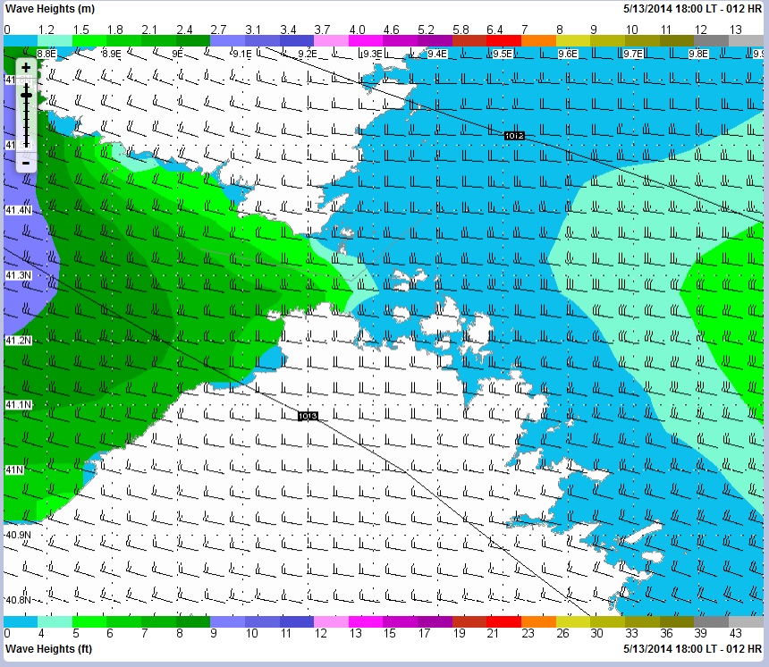
WRI's SeaWeather High Resolution Model charts such as this and the image below add detail, bringing projected conditions to a
more "fine tuned", localized level, adding clarity to the user.
|
One of the bigger issues that a Captain may deal with on a day to day basis is what to do itinerary-wise that is not only fun/entertaining
for the guests, but also comfortable and safe from a wind and sea perspective. When chartering within an island group that has a multitude
of exposures over short distances, these various destinations can produce significantly different weather from one side of an island when
compared to the other side.
|
|
Typical online services often broad-brush forecasted conditions and give only the larger view of the expected weather. This is often fine for more open waters, but if you need to know where it is best to take your clients, you may miss out on important details. SeaWeather.net's in-house computer model runs at a higher resolution than the GFS (Global Forecast System) which is used most often by other online services. Depending on the area in question, the forecast charts are anywhere from 15-24km resolution, whereas the GFS runs at 48km. The end result of this difference is that the WRI model does a far greater job of seeing how this affects conditions on a more localized scale. This will allow the captain to see areas of:
|
|
|
The ability of SeaWeather is that the user can "zoom in" to a particular area to view these individualized effects and nuances in areas
that are not physically far from each other, but may have significant differences from one point to another. This is difficult to do when
looking at a more zoomed out image, or text that tends to broad-brush a larger area, as so often the devil is in the detail.
|
|
Using the high resolution models on SeaWeather.net can help the captain plan an itinerary with his/her guests that will not only be safe
but also pleasurable. To get started, contact WRI for a complimentary 15 day trial today!
|
|
|
2014 Atlantic & East Pacific Tropical Outlook
By: Isaac Pato, Meteorologist
|

|
Atlantic Tropical OutlookThe 2013 Atlantic Hurricane Season will be remembered-for, rather, not remembered-for its below-average number of hurricanes. Despite a quick start to the season in 2013, with Tropical Storm Andrea forming in the e'rn Gulf of Mexico in early June, there were only two Atlantic hurricanes in 2013. Both occurred in mid-September and never strengthened beyond Category 1 strength.On average, the North Atlantic basin sees 12 named tropical cyclones per year, with half of these systems reaching hurricane strength, and of those, about 3 tend to become major hurricanes. With the likelihood of El Nino developing during the early-mid summer of 2014, another below-average Atlantic hurricane season is expected. El Nino tends to result in increased wind shear across the Tropical Atlantic. This tends to prevent tropical waves from strengthening into tropical lows by spreading associated thunderstorms across a larger area. Figure 1 shows that sea surface temperatures across the Gulf of Mexico are below average, likely due to numerous strong cold fronts that pushed through the Gulf during the month of May. This factor will tend to lower probabilities for the development of early-season tropical lows. Additionally, observed warming of equatorial waters across the central and Eastern Pacific is approaching El Nino thresholds, and guidance suggests that warming will continue through the summer, peaking in strength during the August, September, October timeframe. 
Figure 1 - Sea surface temperature anomaly (degree C)
(click to enlarge)
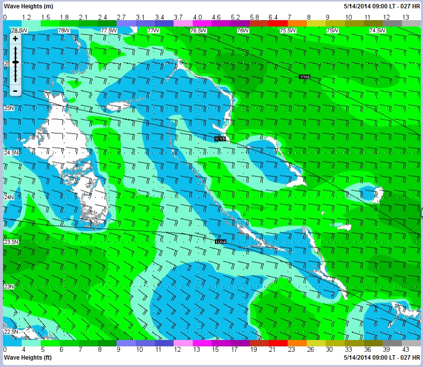
WRI predicts a below-average to near-average Atlantic hurricane season primarily due to the aforementioned effects of El Nino. During the months of June and July, WRI will monitor stalled frontal boundaries across the western Atlantic and Caribbean to be the main focus for tropical development. Into August and September, tropical waves moving w'ward offshore Africa will be monitored for so-called "Cape Verde" type tropical low development. It should be noted that in previous El Nino hurricane seasons such as 1997, tropical waves developed into tropical cyclones at a significantly below-average rate. East Pacific Tropical OutlookHurricane Amanda kicked off the 2014 East Pacific Hurricane season with a vengeance, peaking in strength as a Category 4 storm. WRI forecasts a near-to above normal East Pacific Hurricane season, primarily due to the development of El Nino this summer. Figure 1 shows anomalously warm sea surface temperatures along the coast of Mexico. This, along with reduced wind shear across the Eastern Pacific basin due to El Nino, will tend to result in favorable environmental conditions for the development of tropical lows throughout the 2014 season.WRI ServicesWRI offers many invaluable tools to protect your fleet with safe, efficient transits during tropical season. Our daily tropical summaries keep you informed of potential tropical development up to 7-days in the future. Our tropical and heavy weather monitoring system will alert you to any specific vessels that are threatened by WRI's classified "Tropical Lows" and/or any "officially" classified systems.SeaWeaher's Tropical Tracker and Voyage Planner at www.SeaWeather.net provide worldwide tropical data that you can use to stay informed on all active and potential tropical systems, with your ships' positions plotted on the maps for easy reference. Tropical Tracker includes the following data:

Figure 2 - High-resolution wind data on Tropical Tracker
(click to enlarge)
For any sensitive weather or routing situations, WRI recommends receiving detailed route/weather advisories direct from our team of experienced marine meteorologists. The advisories keep the vessel well aware of upcoming conditions, and ensure travel along the safest and most efficient route. Although below-average tropical activity is expected across the Atlantic basin, it only takes one system to significantly impact a location, or route in the West Atlantic and East Pacific ports. WRI's innovative tools and detailed advisories can provide advanced notice for the early warning required to make informed decisions for a safe and efficient tropical season. Contact WRI today to discuss how our services can be customized for your upcoming trip! |
|
In this issue:
WRI Services:
Contact us for a Forecast!
wri@wriwx.com
+1-518-798-1110
Visit the new SeaWeather and request a trial!
Racing Forecasts for Racers
WRI Fishing Charts for Anglers!
Marina Forecasts
Heavy Weather Alerts
WRI Meteograms
 Need a Forecast?
Contact our professional meteorologists
Need a Forecast?
Contact our professional meteorologists
24 hours a day, 365 days a year at
(518) 798-1110
or wri@wriwx.com


Unsubscribe
WRI Services:
Contact us for a Forecast!
wri@wriwx.com
+1-518-798-1110
Visit the new SeaWeather and request a trial!
Racing Forecasts for Racers
WRI Fishing Charts for Anglers!
Marina Forecasts
Heavy Weather Alerts
WRI Meteograms
Need a Forecast?
Contact our professional meteorologists24 hours a day, 365 days a year at
(518) 798-1110
or wri@wriwx.com
Unsubscribe