2026 Atlantic Tropical Season Outlook
Luke Morin, Meteorologist
With summer approaching, we near the beginning of the Atlantic Hurricane Season, which starts June 1, peaks in September, and ends November 30. As a reminder, key conditions that support tropical development include:
- Low vertical wind shear
- Warm sea surface temperatures (26.5°C / 80°F or higher)
- High atmospheric moisture content
Why is 2026 forecast to be a below average year?
Factor #1: The main reason for the quieter forecast is the expected development of El Niño conditions in the Equatorial Pacific. El Niño typically increases vertical wind shear and stronger upper-level westerly winds across the Caribbean and Gulf of Mexico, making it harder for storms in the Atlantic to organize and strengthen.
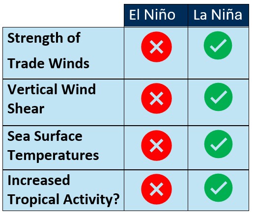
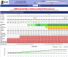
Figure 1: Impacts of ENSO on the components of tropical development. Green checks denoting conditions favorable for development, with red X’s denoting conditions unfavorable for development.
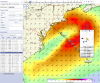
Factor #2: Sea surface temperatures (SSTs) are near normal to 1°C above average across much of the Caribbean, while the Gulf of Mexico is running 1–2°C above normal. In contrast, SSTs across the Central and Eastern Tropical Atlantic are near normal to 1°C below average, a pattern expected to continue through the 2026 season. Cooler Atlantic SSTs can strengthen the subtropical high-pressure system, leading to stronger trade winds and increased wind shear across the Tropical Atlantic, which can inhibit storm development.
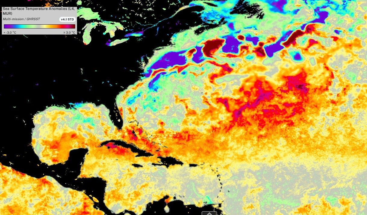
Figure 2: Sea surface temperature anomalies across the Atlantic basis May 06th 2026.
Factor #3: A more active West African Monsoon is expected, transporting tropical moisture northward into northwestern Africa. A stronger monsoon can enhance the second half of the Atlantic Hurricane Season by producing westward-moving tropical waves, which often serve as the “seeds” for tropical cyclones when environmental conditions are favorable.
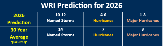
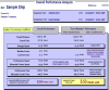
Figure 3: Official WRI Tropical Atlantic Basin predictions for the 2026 Season.
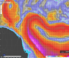
Early-season development in June will likely occur closer to North America, where wind shear is lower and sea surface temperatures are warmer than across the open Atlantic and Caribbean.
By July and August, ENSO conditions are expected to shift to more of a moderate El Niño, while Caribbean Sea surface temperatures remain average to slightly above average. This should allow tropical development to expand into the Caribbean and western Tropical Atlantic.
From September through November, development is expected to shift farther east into the Tropical Atlantic as an active West African Monsoon generates repeated tropical waves near the Cape Verde Islands. However, moderate to strong El Niño conditions and cooler-than-average SSTs in the Central and Eastern Atlantic should limit storm intensification.
These tropical waves typically follow one of two paths:
- West-northwestward into the Caribbean, Gulf of Mexico, and North America
- Northwestward or northward into the open Atlantic, potentially affecting the U.S. East Coast, Canadian Maritimes, Europe, and trans-Atlantic shipping routes.
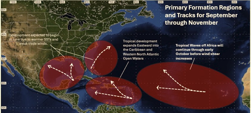
Figure 4: Potential tropical tracks through as the season progresses.
When tropical weather threatens operations, clients rely on WRI for accurate, continuous monitoring and forecasting. Our team of degreed meteorologists delivers clear, concise, and timely guidance to support route planning, port operations, and critical decision-making.
WRI helps our clients make informed operational decisions with confidence, maintaining direct communication with both shore-side operations and vessels to ensure the latest information is delivered quickly. WRI provides:
- Four daily updates on classified tropical systems
- Early monitoring and reporting on tropical lows and disturbance areas before official classification by forecasting agencies
- Daily tropical summaries for the Atlantic Ocean basin around 0900UTC
- Participation in conference calls with operations teams to aide in quick and informed decision-making
- Access to the Tropical Tracker tool on our Dolphin platform - enabling real-time visualization of active systems relative to your vessels
Please contact WRI with any questions or concerns regarding any tropical development. We are available 24/7 and more than happy to help!