Select an edition to view:


2025 East Pacific Tropical Season Outlook
Jared Young The East Pacific Hurricane Season is already in full swing for 2025. The official East Pacific Hurricane Season runs from 15 May through 30 November, with peak tropical activity falling between July and early September in this basin. Over the last 30 years, there have been an average of 15 named tropical cyclones, 8 hurricanes (Category 1-2) and 4 major (Category 3-5) hurricanes in the East Pacific annually. For the 2025 season, we are expecting a slightly below average season due to the current weak La Niña to Neutral condition of the El Niño Southern Oscillation (ENSO). To obtain tropical development in a given region, the following “ingredients” have to be present:
The current weak La Niña to Neutral ENSO status is expected to persist into at least Fall of 2025, and this is expected to produce slightly below average tropical activity in the East Pacific for the following reasons:
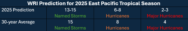
Figure 1: WRI's predicted storm totals for the 2025 East Pacific Tropical Season When and where can we expect Tropical Development? Tropical development usually originates east of 100W and north of 10N offshore the coastal waters between Mexico and Costa Rica, with systems tracking WNW’ward until reaching roughly 105-110W. Tropical cyclones will then usually either continue WNW’ward from this point or lift NNW’ward towards the Baja Peninsula and Sea of Cortez, weakening thereafter while entering cooler sea surface temperatures and stronger vertical wind shear within subtropical high pressure ridging offshore the W'rn United States. Sea surface temperatures east of 100W are currently slightly warmer than average and more suitable for tropical development, however. In instances where vertical wind shear weakens over these waters and the atmosphere has high amounts of moisture content suitable for deep convection, tropical development is still very possible. We have already seen this in the 2025 season with recent systems such as Tropical Storm Alvin, Hurricane Barbara and Tropical Storm Cosme, which were able to develop into named storms while meandering WNW’ward offshore Central America through this region of warmer sea surface temperatures.
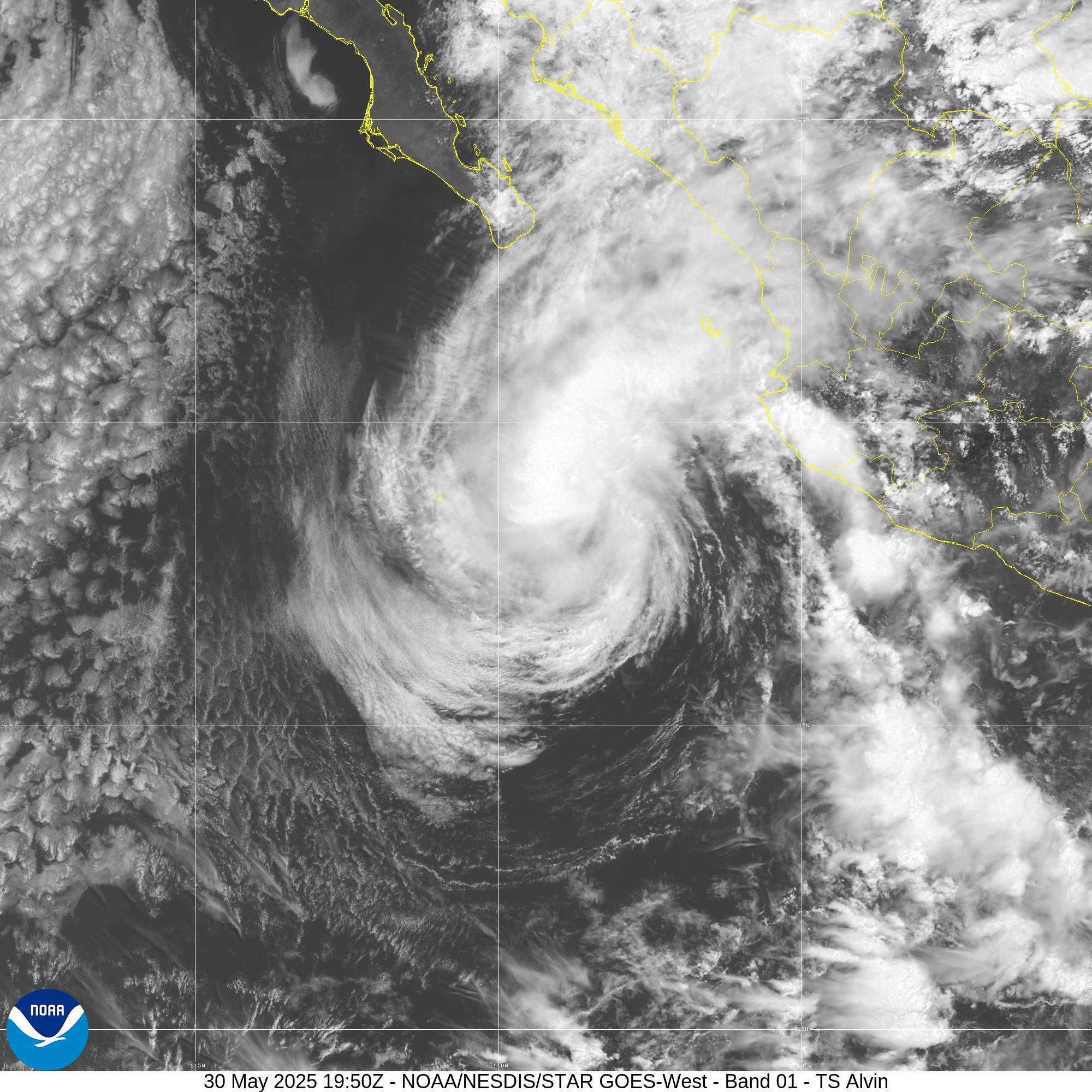
Figure 2: Tropical Storm Alvin offshore the coast of Oaxaca on May 30th, 2025. Picture courtesy of NOAA/NESDIS WRI and our team of meteorologists will continue to work diligently to keep you updated of any tropical threats throughout the 2025 Eastern Pacific Hurricane Season. Clients who utilize WRI's customized forecasting services or subscribe to SeaWeather.net will receive complimentary tropical alerts and daily basin summaries for the East Pacific to ensure you and your crew, vessel, and clients stay safe throughout your summer itineraries. |

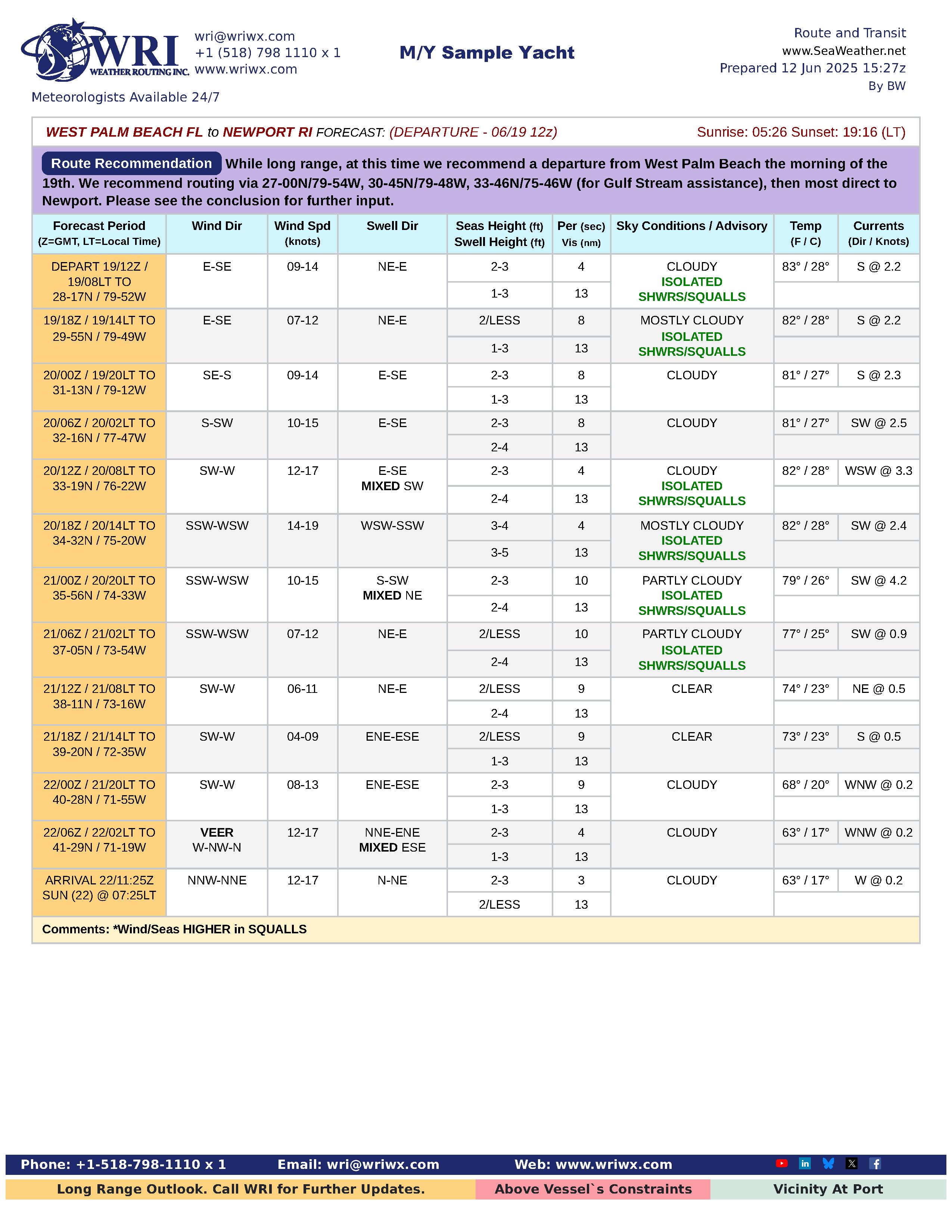
A New Look to Forecasts
Kyle Petroziello, Senior Meteorologist WRI is happy to have introduced a modernized and cleaner look to our popular PDF forecasts this month. We are confident the updated look will allow for smoother understanding with better organization of material, graphics, and forecast tables. Within the forecasts, notable features include:
Please click on each of the pages below to view a larger version. We welcome all and any type of feedback on the new presentation style, as we continue to aim to tailor weather information in a style that best suits your needs. Please let us know to our email wri@wriwx.com.
|
| Upcoming Events | |||
|
| Product/Services | ||||||||
|
||||||||
| NEW SeaWeather App | ||||||||
|